Kauai, Hawaii by helicopter
- Lyndell Daniel
- May 8, 2019
- 5 min read
Updated: Feb 7, 2021
We were so looking forward to the helicopter flight. We had taken the helicopter (doors off) on the Big Island to see the volcano and what an experience. Our pilot on The Big Island was an ex Airforce Pilot and he certainly gave us a thrilling ride.
If you've been following any of my other blogs, you will know we always hire a car (which our friends give us a hard time over, but we like road tripping). I'm always the driver and my husband the navigator - well yes, it took about 5 U-turns and stops to find the place for the helicopter tour (which really was quite easy to find, as it was on the main road). The navigator is putting it down to a very early morning start after a long haul flight.
My one piece of advice to photographers taking the helicopter flight, use a wide angle lens. I had the choice between my 24-70mm or my 10-20mm and chose the 24-70mm. The wider angle would have been a much better choice.

Mauna Loa Helicopter tours were very professional and we had the most amazing time with our Pilot. Just remember, doors off and very cold on the early morning flights. Tie that hair up (well Peter's is gone, so no problem there), don those long pants and jumpers and keep everything inside the helicopter, believe me that wind swirls around those back seats. At one point, I leant a little too far or close really to the open door and thought I'd almost lose my camera, which has to be on a strap and around your neck or tied to your hand - so a quick readjustment and I was still inside the helicopter.

A lot of Kauai’s most beautiful geographical wonders are inaccessible by roads or trails, but can be viewed from the air, which helps you discover the most awe-inspiring beauty of this hidden paradise. After a briefing we took off to the south towards the coastline, providing us with a fantastic view of the airstrip.

In the air, we had our first glimpses of the rugged cliffs and amazing blue water inlets. We had chosen the 1 hour private Island Tour, which took us across the Nā Pali Coast, above the deep colourful gorges of Waimea Canyon, to the magnificent Manawaiopuna (“Jurassic”) Falls, and, the breathtaking Mt. Waiale’ale Crater, which is the site of Kauai’s last volcanic eruption 4 million years ago. We were so lucky with the weather, as the helicopters hadn't been able to fly into the Crater for weeks.

The Manawaipuna Falls from the helicopter. This natural wonder is commonly referred to as “Jurassic Falls,” and is a breathtaking sight to behold. The water cascades from an approximate 400-foot tall cliff surrounded by rich flora and is located within Hanapēpē Valley on the westside of the island. This was just one of the many falls that we encountered.

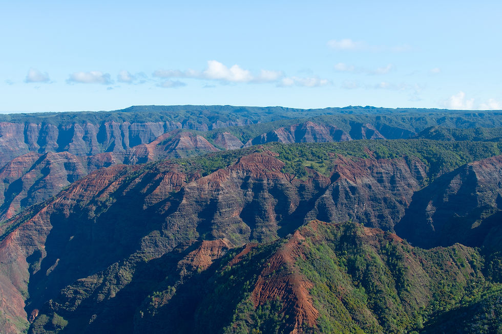


Check out my blog Waimea Canyon, which is located on the southwest side of Kauai in Waimea. It was fantastic being able to see the canyon from the air and then drive to the canyon and take in some of the wonderful hikes.

I thought it would be hard to beat the scenery of the Canyon and Crater from the air, but when we hit the Nā Pali Coast, the views were incredible. The mountains stood tall and loomed in front of the helicopter, while the backdrop of blue and turquoise waters spanned to the horizon. There was some haze on the morning of the flight, but this did not detract from any of the stunning scenery, and with the sun hitting the water and mountains, it was hard not to sit back and stare at this massive coastline in awe.

The pilot ensured he moved and dipped the helicopter so we both had views of this remarkable coastline.

You start to appreciate the magnitude of the surrounding mountains, when you see the boats skimming along the water below where the cliffs drop into the sea.


The Nā Pali Coast is about 90 minutes north of Lihue.

Spanning 17 miles along Kauai’s North Shore, the Nā Pali Coast is a sacred place defined by extraordinary natural beauty. These emerald-hued cliffs with razor-sharp ridges tower above the Pacific Ocean, revealing beautiful beaches and waterfalls that plummet to the lush valley floor.


The rugged terrain appears much as it did centuries ago when Hawaiian settlements flourished in these deep, narrow valleys, existing only on the food they could grow and the fish they could catch.

Anyone who has been there knows – Nā Pali Coast is one of the true wonders of the world.

There are many ways to explore the Nā Pali Coast, but the safest access and best views are found by sea or by air.

Much of Nā Pali is inaccessible due to its characteristic sheer cliffs that drop straight down, thousands of feet into the ocean. This, and its remote location, allow Nā Pali to remain one of the most beautiful and pristine coastlines in the world.

You can snorkel, kayak, take a day or half day cruise, take a charter for a sunset dinner, and participate in so many more water activities along the Nā Pali Coast. Water activities will be on our list for the next trip to Kauai.
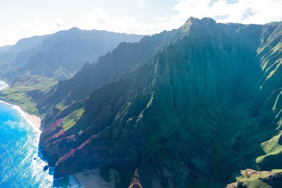
Nāpali Coast State Wilderness Park lies in the northwest of Kauai Island, Hawaii. It’s known for its towering pali, or sea cliffs, punctuated by narrow valleys, streams and cascading waterfalls.

Can you imagine having to come to work and see these views each day.......

One of the wettest spots on Earth, Kauai's Mount Waialeale offers a challenging hike filled with misty lush green surroundings and movie-worthy sights. And if you're a hard-core hiker you'll enjoy an up-close-and-personal look at a series of enchanting waterfalls.
The base of Mount Waialeale, also known as the Blue Hole, is referred to as the Wailua Headwaters by locals; it's where you see the falls coming down the wall. This verdant wall is also known as the Weeping Wall; and if you see it, you'll understand why. This hike is certainly for advanced hikers.

This is one of the times my wide angle lens would have been magical. Looking down into crater - we actually flew to the very end and down into the crater, a memorable experience. It is thrilling to be so close to the overpowering cliffs that rise up towards the sky. Mount Waialeale is a shield volcano and the second highest point on the island of Kauaʻi. Its name literally means "rippling water" or "overflowing water". The mountain, at an elevation of 5,148 feet (1,569 m), averages more than 373 inches (9,500 mm) of rain a year.


Comments